Crowberry Bog
Categories
Pacific Northwest (AK, ID, OR, WA)
About
GENERAL INFORMATION
Criteria:
- Listed on more than one “valuable wetland” list by natural resource agencies or nongovernment organizations.
- Protects biological diverse wetland flora, fauna and/or their habitat
- Rare or unique wetland type within its own biogeographical region
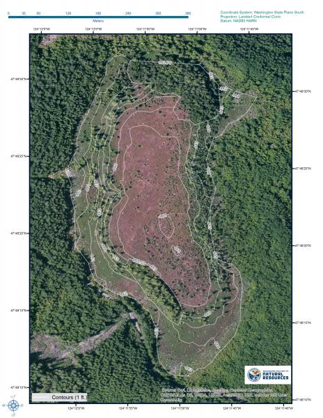
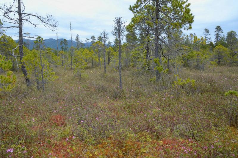
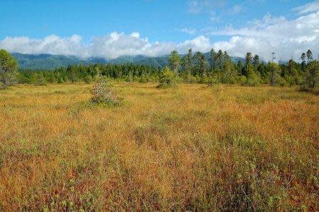
Crowberry Bog is located above the Hoh River on the western Olympic peninsula. This site is the only documented raised bog in the western, contiguous United States and the southernmost in western North America. The highest point of the bog is approximately 9 feet higher than the lowest point of its outer margin. Furthermore, it appears to be a rare type of raised bog called a plateau bog, which is only found in areas with a strong oceanic climate such as northeastern North America and the Baltic region of Europe. Three globally rare plant communities, the globally rare Makah Copper butterfly (Lycaena mariposa ssp. charlottensis), and two state rare mosses (Sphagnum austinii and Splachnum ampullaceum) are found at the bog. Because of these important features, the Washington Department of Natural Resources, Natural Heritage Program (DNR-Natural Heritage) has designated this site as a state Natural Area Preserve. Natural Area Preserves are managed by the Washington Department of Natural Resources, Natural Areas Program to protect the best remaining examples of ecological communities and rare plant and animal species.
Exemplary Ecosystem Services:
- Aesthetic/cultural heritage value/ provisioning
- Education
CONSERVATION STATUS AND THREATS
Conservation status: State/Province/Regional Protection
Adjacent Land Use: Upland Forest/Woodland
Approximate natural buffer width:
> 100 ft
ECOLOGY
Approximate size: Approximately 12 hectares
General wetland characterization:
Inland Fresh Bog
Name of body of water: Hoh River
Surficial Geology:
Crowberry Bog occurs on glacial drift derived from alpine glaciers of Fraser age. These drift deposits occur on a plateau above surrounding deposits of glacial outwash and alluvial deposits associated with the Hoh River. The Olympic Mountains were covered by a solid ice cap during Quarternary glaciation (Heusser 1974). Alpine glaciers, derived from this ice cap, flowed down the major river valleys. More than 47,000 years ago, the Hoh river valley was glaciated to its present day mouth. About 19,000 years ago the retreating ice terminus stagnated in the general area in which the pNAP occurs (Heusser 1974). Ice blocks left in this area did not melt for another 3 to 4, 000 years at which point wetland development was initiated (Heusser 1974), ultimately leading to the development of the raised bogs that are present today. A morainal deposit is mapped as occurring on the eastern side of Hoh Bog. A similar landform occurs east of Crowberry Bog but is not mapped as morainal deposit.
Soils:
Soils in Crowberry and Hoh Bogs are mapped as Orcas peat deposits which are derived from Sphagnum species (USDA 1975). A peat core from Crowberry Bog indicated that Sphagnum-derived peat extends to a depth of 12.5 feet (3.8 meters; Heusser 1974). Below the Sphagnum peat is a layer of muck extending another three feet (1 meter) in depth followed by a mix of muck and clay which extends to the bottom of the wetland basin at a depth of 19 feet (5.8 meters; Heusser 1974). A core from Hoh Bog showed Sphagnum-derived peat to a depth of 6.5 feet (2 meters) followed by 2 feet (70 cm) of muck then 1.5 ft. (50 cm) of muck/clay mix and at the bottom was a clay layer (Heusser 1974). Soils around the bogs and on top of the glacial drift are mapped as the Lagitos-Klone-Tealwhit soil complex which consists of clayey or fine-texture old alluvium (USDA 1975; DNR 2014). This complex consists of poorly drained, somewhat poorly drained silty loam over sand and gravel, and well-drained gravelly loam derived from glacial outwash (DNR 2014).
Citations:
DNR 2014. Soils GIS layer derived from the Private Forest Land Grading system (PFLG) and subsequent soil surveys. Washington Department of Natural Resources, Olympia, WA.
Heusser, C.J. 1974. Quaternary Vegetation, Climate, and Glaciation of the Hoh River Valley, Washington. Geological Society of America Bulletin v.85, pp. 1547-1560.
USDA 1975. Soil Survey of Jefferson County Area, Washington. U.S. Department of Agriculture, Soil Conservation Service in cooperation with the Washington Agricultural Experiment Station.
Heusser, C.J. 1974. Quaternary Vegetation, Climate, and Glaciation of the Hoh River Valley, Washington. Geological Society of America Bulletin v.85, pp. 1547-1560.
FLORA AND FAUNA
Dominant flora: bog laurel (Kalmia microphylla), Labrador tea (Ledum groenlandicum), crowberry (Empetrum nigrum), cranberry (Vaccinium oxycoccos), roundleaf sundew (Drosera rotundifolia), cottongrass (Eriophorum chamissonis), white-beakred rush (Rhynchospora alba), western hemlock (Tsuga heterophylla), shore pine (Pinus contortra var. contorta), beargrass (Xerophyllum tenax), skunkcabbage (Lysichiton americanus), rusty peat moss (Sphagnum fuscum), and red peat moss (Sphagnum rubellum)
Unique flora: A couple of rare species: state rare mosses (Sphagnum austinii and Splachnum ampullaceum), state rare plant (Carex stylosa). The presence of beargrass in the bog is unusual.
Dominant fauna: Roosevelt elk and black bear frequent the site.
Rare fauna: globally rare Makah Copper butterfly (Lycaena mariposa ssp. charlottensis)
ADDITIONAL INFORMATION
Crowberry Bog Proposed Natural Area Preserve Natural Area Recommendation
Images