Bunchgrass Meadows Research Natural Area
Categories
Pacific Northwest (AK, ID, OR, WA)
About
- Listed on more than one “valuable wetland” list by natural resource agencies or nongovernment organizations.
- Protects biological diverse wetland flora, fauna and/or their habitat
- Rare or unique wetland type within its own biogeographical region. (Meeting this criteria would include, but is not limited to, wetlands with unique hydrology or chemistry that make it rare within its own region)
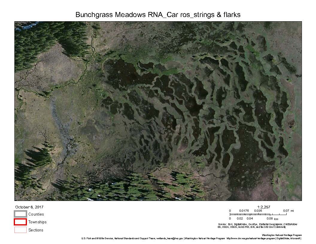
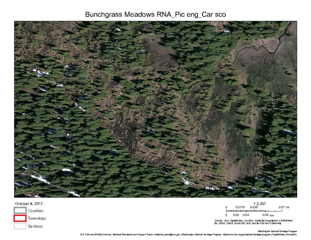
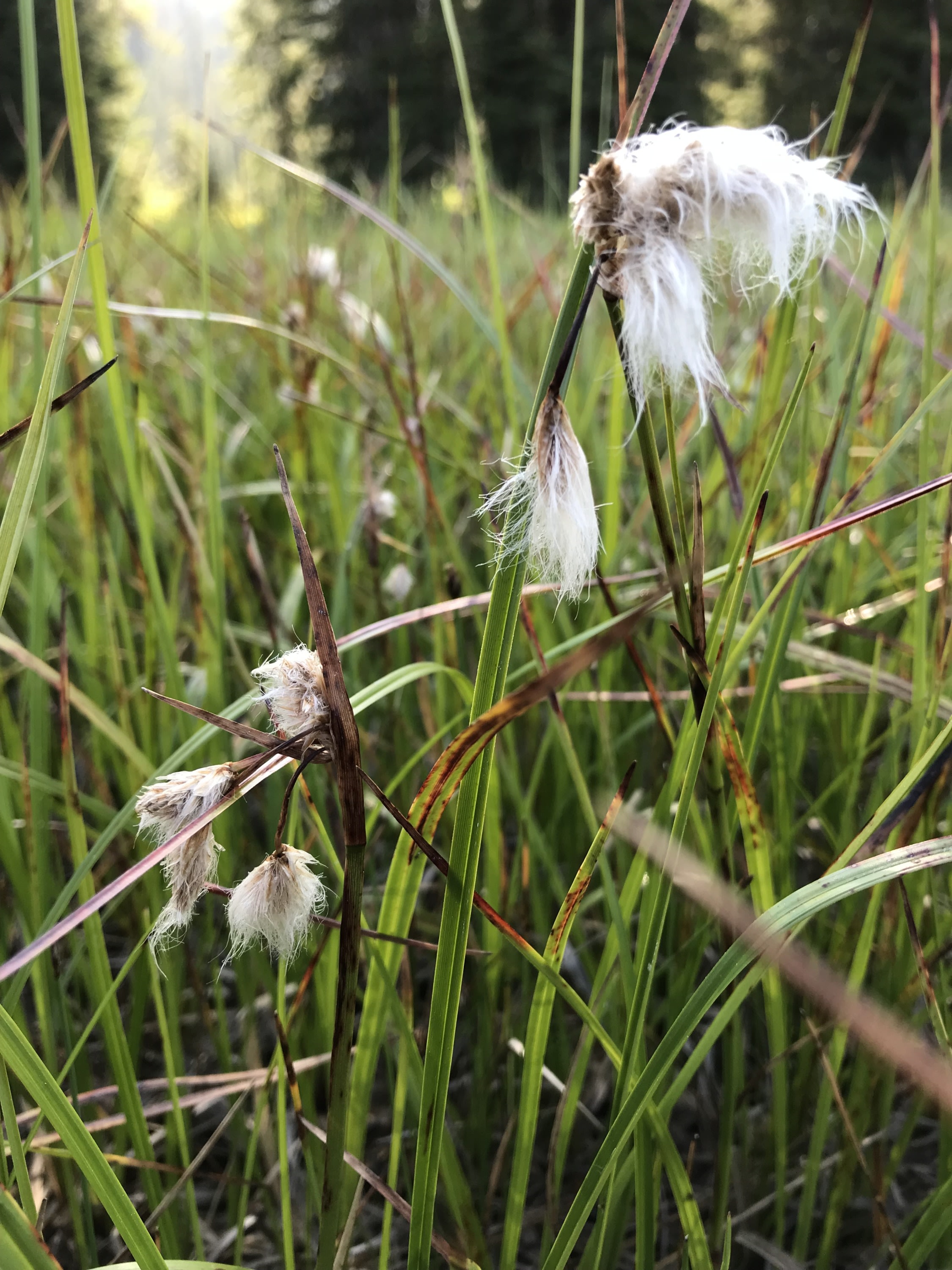
This relatively large RNA (711 acres [288 hectares]) includes a substantial wetland complex containing rare native plant communities listed by the Washington State Department of Natural Resources (WDNR) in it’s Washington Wetlands of High Conservation Value database in the headwaters of the Harvey Creek Watershed. Rare wetland plant communities identified and mapped as being of high conservation value by the WDNR include Carex aquatilis var. aquatilis fen; Picea engelmannii/Carex scopulorum var prionophylla swamp woodland; Carex scopulorum var prionophylla fen; Carex utriculata fen; Eleocharis quinqueflora fen; Salix farriae/Eleocharis quinqueflora shrub fen; Calamagrostis canadensis western wet meadow; Danthonia intermedia wet meadow; Carex limosa fen; Carex rostrata fen; and Eriophorum angustifolium ssp. angustifolium- Eleocharis quinqueflora/Sphagnum spp. fen. The wetland component includes perhaps the farthest south patterned peatland in the coterminous USA.
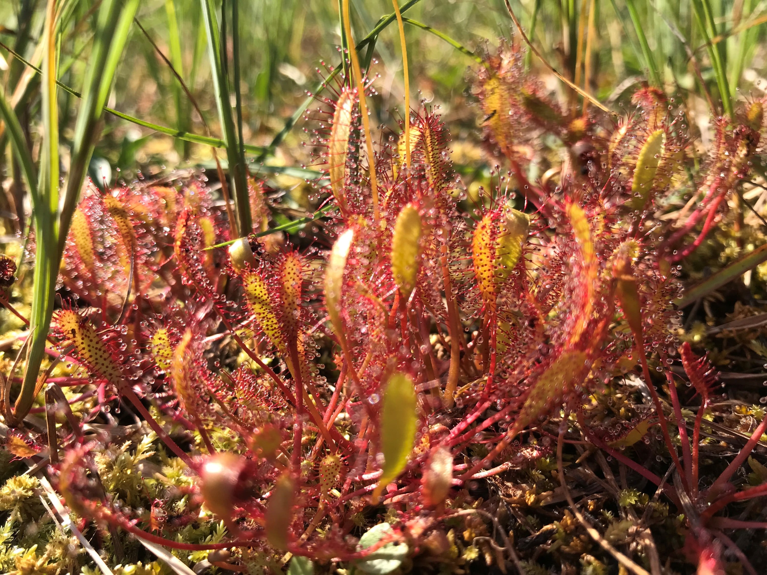
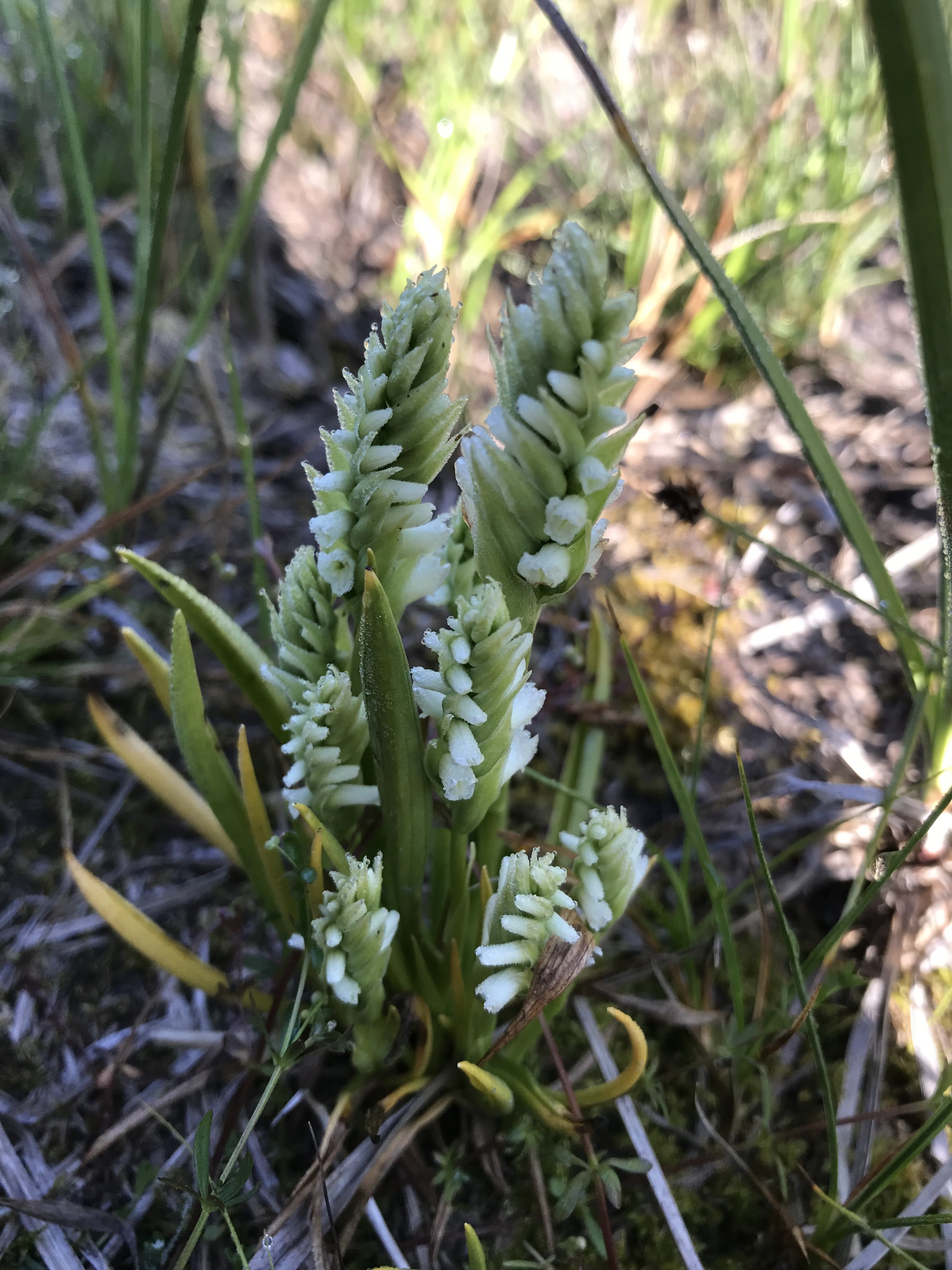
The high elevation bog component of the wetland was identified as a high conservation need (at p. 72 & 73) in the 2007 Department of Natural Resources Natural Heritage Plan for the Canadian Rockies Ecoregion in which it occurs. The wetland complex and rest of the RNA were established as a U.S. Forest Service RNA (Colville National Forest) in recognition of these attributes in 2008 (see BunchgrassMeadowsRNA_Est Rec_USFS 2008.pdf). The peatland and other elements of the wetland complex provide habitat for a number threatened and endangered or sensitive animals listed by the U.S. Fish and Wildlife Service and U.S. Forest Service including woodland caribou (Rangifer tarandus caribou), Canada lynx (Lynx canadensis), bull trout (Salvelinus confluentus), grizzly bear (Ursus arctos horribillus), gray wolf (Canis lupus), Townsend’s big-eared bat (Corynorthinus townsendii), peregrine falcon (Falco peregrinus anatum), wolverine (Gulo gulo luteus) fisher (Martes pennanti), redband trout (Oncorhynchus mykiss), and great gray owl (Strix nebulosa) (at p. 2 USFS EnvAssmt.pdf)As noted above, the high quality native plant communities identified by the WDNR with the Bunchgrass Meadows RNA enable this wetland to support populations of a number of federally-listed threatened, endangered or sensitive plants and animals. Multiple natural resource management agencies have compiled documentation on the unique structure and composition of this wetland that successfully supported the nomination of this wetland as part of the Bunchgrass Meadows RNA. I have been a student of peatlands for over thirty years beginning with climate change research on the North Slope in Alaska and continued to enjoy studying these wondrous and important systems. The montane wetland complex within the Bunchgrass Meadows RNA in the headwaters of Harvey Creek are among the most well preserved and diverse that I have ever seen and worthy of inclusion as a wetland of distinction.
- Maintains ecological connectivity/cohesion
- Aesthetic/cultural heritage value/provisioning
- Recreation (birdwatching, ecotourism)
- Aquifer recharge
- Flood storage/mitigation
- Carbon storage
- Water quality improvement
- Education
The U.S. Forest Services establishment record document (BunchgrassMeadowsRNA_EstRec_USFS 2008.pdf) and WDNR’s 2007 and 2011 Natural Heritage Plans (Natural Heritage Plan_WDNR 2011.pdf) and Washington Native Plant Society plant list (WNPS Plt List_Bunchgrass.pdf) as well as those document listed as evidence of List 1 clearly indicate that this is a unique area that goes well above and beyond by providing the habitat provisioning and other listed services.
The wetland complex is protected in perpetuity within the Colville National Forest as a designated Research Natural Area.
- Pond
- Stream
This montane wetland complex in the headwaters of Harvey Creek in northeastern Washington contains multiple hydrogeomophic wetland types (riverine, lacustrine, slope, and depressional) that provide an exceptionally structurally rich and diverse array of wetland habitat types. Please visit the WNDR Wetlands of High Conservation Value at https://wadnr.maps.arcgis.com/apps/webappviewer/index.html?id=5cf9e5b22f584ad7a4e2aebc63c47bda and enter the search terms “Bunchgrass Meadows, WA.” Then you can see the mapped wetlands of high conservation value and unique structure and diversity of this wetland by turning on the imagery layer and zooming in. You will not be disappointed.
See the description of surficial geology in the establishment record beginning on p. 45.
Mapped soil types include a combination of mineral and organic soils, including ponded Borosaprists; Manley silt loam; and Uncas muck; .
Images