Buckhorn Island State Park
About
GENERAL INFORMATION
Criteria:
Listed on more than one “valuable wetland” list by natural resource agencies or nongovernment organizations.
Protects biological diverse wetland flora, fauna and/or their habitat
Supports significant numbers of wetland-dependent fauna, such as water birds or fish
Rare or unique wetland type within its own biogeographical region. (Meeting this criteria would include, but is not limited to, wetlands with unique hydrology or chemistry that make it rare within its own region)
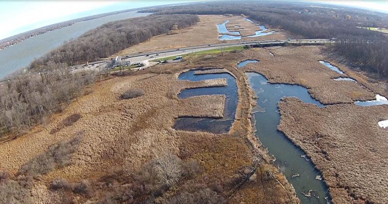
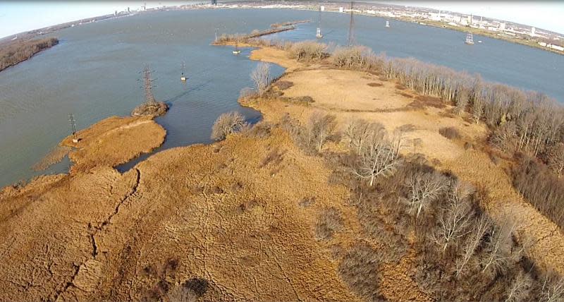
Buckhorn Island State Park (BISP) is located approximately 3.5 miles upstream of Niagara Falls, at the northwestern tip of Grand Island New York, where the western and eastern branches of the Niagara River re-converge. BISP is an 895-acre state park comprised of a variety of riverine wetland, meadow, and forested habitats. BISP contains the largest remaining riverine emergent wetland that is still hydrologically connected to the 24.8 mile Niagara River, as well as ecologically unique forested wetland and wet meadow habitats that were once abundant along the entire length of the Niagara River corridor. In 1987 the NY Department of State Office of Planning and Development listed the BISP as a “Significant Coastal Fish & Wildlife Habitat,” as recommended by the NY State Department of Environmental Conservation. BISP provides critical off-channel spawing and feeding habitat for a variety of warm water fisheries species in the region including Pike, Muskellunge, and Bass.
BISP is located within a major Great Lakes migratory bird route and falls within the globally significant, internationally recognized, Niagara River Corridor Important Bird Area (IBA) and the NY State designated Buckhorn Island Bird Conservation Area (BCA). An IBA is designated as such by the National Audubon Society because it provides essential habitat for one or more species, endemic species, species representative of a biome, or significant concentrations of breeding, wintering, or migrating birds. The Niagara River supports one of the world’s largest concentration of gulls, with 19 species and over 100,000 individuals recorded, and more than 25 species of waterfowl including critical nesting habitat for several state-listed threatened avian species. BISP is open year-round from dawn to dusk; public uses include hiking, biking, bird-watching, fishing, kayaking, canoeing, and cross-country skiing.
Exemplary Ecosystem Services:
Maintains ecological connectivity/cohesion
Recreation (birdwatching, ecotourism)
Carbon storage
Education
CONSERVATION STATUS AND THREATS
Conservation status: State/Province/Regional Protection
Adjacent Land Use: Residential - medium density
Approximate natural buffer width:
> 100 ft
Other information:
BISP is bordered on two sides by the Niagara River channel and floodplain (East and West Branches) and on two sides by light residential land use. I-190 bi-sects the BISP into two pieces through the approximate center of the Park. The emergent wetland in the Park has two water control structures installed in 1987.
Is there any other information that should be conveyed regarding your nomination of this wetland?
The Niagara River corridor is essentially an ecological disaster zone when it comes to riparian wetlands due to the extremely heavy industrial manufacturing and urban development legacy associated with cheap power production at Niagara Falls over the last ~150 years (e.g., the region is home to the country's first superfund site!). In a part of the world where reference standard wetlands are slim to none, this is one of the most intact and critical wetland ecosystems for birds and fish that we have on the Nigara River, despite its impairments (i.e., altered site hydrology and geomorphology from dam operations, invasive species etc.).
ECOLOGY
Approximate size: 362
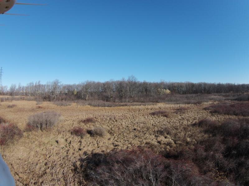
General wetland characterization:
Inland Fresh Meadow
Inland Shallow Fresh Marsh
Inland Deep Fresh Marsh
Inland Open Fresh Water
Inland Fresh Shrub Swamp
Inland Fresh Wooded Swamp
Adjacent Water Bod(ies):
Pond
Stream
Name of body of water: Niagara River
Surficial Geology:
The surficial geology of the Buckhorn Island State Park wetlands is the result glacial events during the Pleistocene epoch. Features are identified in the Niagara River region from the Wisconsin stage of the event about 12,000 years ago, prominent among these are various moraines, glacial lakes (both extant and extinct) and till deposits. The Buckhorn Island wetlands are mapped by the U.S. Geological Survey (USGS) as 100% unconsolidated till deposits with variable textures from boulders to silt that is poorly sorted, sand-rich diamict deposited beneath glacial ice. Permeability of the till material is a function of the level of local compaction with thickness of the deposits varying throughout the Niagara River region from approximately 3 to 164 feet depending on location. These glacial till deposits have been re-worked by the floods of the Niagara River with sorting and stratification across Buckhorn Island wetlands typical of a large riverine floodplain geomorphic landscape position. The area is mapped by the U.S. Geological Survey (USGS) as 100% unconsolidated till deposits with variable textures from boulders to silt that is poorly sorted, sand-rich diamict deposited beneath glacial ice (Cadwell 1986a, 1986b).
If Adjacent to Stream, insert stream order: 4th or maybe 5th?
Soils:
The Buckhorn Island State Park is mapped as relatively flat, with very little local variation (less than 6 feet) in elevation, and consists of several mapped United States Department of Agriculture (USDA) Soil Survey Geographic database (SSURGO) soil unit types. The primary soil types in BISP are ponded Haplaquolls, Raynham silt loam, 0 to 3 % slopes, Canandaigua silt loam, and open water.
FLORA AND FAUNA
Dominant flora: Populus deltoides, Fraxinus pensylvanica, Acer rubrum, Salix sp., Cephalanthus occidentalis, cornus stolinifera, Lonicera, Typha sp., Phragmites australis, carex stricta, calamagrostis canadensis.
Unique flora: NY State listed edangered species - Iris virginica var. shrevei is confirmed within the BISP. A rare habitat type for the Niagara River - Carex stricta wet meadow; regionallly unique "wet Oak-Hickory" forested riparian wetland assemblage per Patricia Eckel's botanical description; numerous Carya ovata as bat habitat
Dominant fauna: White tail deer, Osprey, Waterfowl, Pike, Muskellunge, Bass
Rare fauna: 10 species of "rare" freshwater mussels were documented in the Niagara River and the aquatic zones surrounding the BISP by the NY Natural Heritage Program.
ADDITIONAL INFORMATION
Coastal Fish & Wildlife Habitat Rating
Coastal Fish & Wildlife Habitat Rating (Buckhorn Island - Goat Island Rapids)
Coastal Fish & Wildlife Habitat Rating (Grand Island Tributaries)
Coastal Fish & Wildlife Habitat Rating (Buckhorn Island Tern Colony)
Important Bird Areas
Use of Buckhorn March and GI Tributaries by Northern Pike for Spawning and as a Nursery
Images